Ateliers for Research and Creation (ARC)
ARC Mapping Religiosity in the Suburbs of Beirut
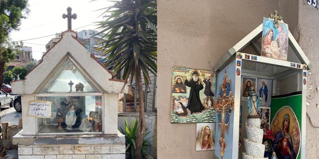
Photos taken by Raphael Lteif in May 2024.
Atelier for Research and Creation · Archived ARC
- Closed ARC: no longer open for enrolment
- From September 2024 to July 2026
- Last semester: 2025-2026. Semester 2
- Directed by Michael Davie, PhD
Code: ARC1042-1
Lead teacher-researcher
Michael F. Davie, PhD
michael.davie@alba.edu.lb
Duration: from September 2024 to July 2026
Description
The aim is to map all the material expressions of religious affiliation in the immediate suburbs of Beirut. This involves describing, recording, photographing and, above all, locating by GPS positioning all the informal places of worship (cabellas, mazars) and all the other markers of religious affiliation: political banners, but exclusively those with a religious connotation, verses from holy books, portraits of saints, martyrs and clergymen, icons, inscriptions, tags, memorials, statues and statuettes, etc. The surveys will deal exclusively with objects visible from the street. The districts of Sinn el-Fil, Dekwané and Nabaa will serve as the setting for the surveys. These data will be processed using a Geographic Information System.
All disciplines have their place in this research, each contributing an explanatory angle: architects (methods for describing materials and construction techniques); interior architecture and design (analysis of styles, influences and histories); graphic arts (reading objects and their visual contexts); cinema (analysis of the techniques used to make objects visible); illustration and multimedia (the relationships between object and viewer); fashion (analysis of the relationship between society and the externalisation of the message); urban planning (analysis of the place of objects in the city and of its networks).
Introduction
The city of Beirut has very often been analysed by means of approximations and postulates never supported by precise field observations. Religion has been one of the favoured entry points for “explaining” the city: “East Beirut, Christian; West Beirut, Muslim” is a favourite media cliché. Yet the material expression of religion and its staging in public space have very little to do with faith, a very intimate domain of the individual’s relationship with the spiritual world.
This research aims to map all the material expressions of religious affiliation in the immediate suburbs of Beirut. This involves describing, recording, photographing and, above all, locating by GPS positioning all the official places of worship (churches, mosques…) and informal ones (cabellas, mazars), as well as all the other markers of religious affiliation: political banners with a religious connotation, verses from holy books affixed at building entrances, portraits of saints, martyrs, clergymen, etc.
The inventory will be limited to what is visible to a pedestrian (or a car passenger) along the city’s streets and alleyways, without ever entering the intimacy of domestic space. In other words, the aim is to describe what visitors see at their own scale, but without conducting an enquiry into the formal or private religious affiliations of the inhabitants or residents of the city’s suburbs.
The importance of this project lies in an attempt to pool several approaches (sociological, architectural, anthropological, political science, cartographic, historical and urban planning, but also approaches from media studies, design, art history, cinema, etc.). This pooling will result in a series of maps (“overlays” or “layers”) obtained by processing the survey forms with a Geographic Information System (GIS). These maps will make it possible to arrive at very fine-grained analyses of one of the facets of the identities materially expressed by the residents of the suburbs’ various neighbourhoods. By extension, this staging of identity is obviously part of a political game, but above all it will make it possible to grasp the place of the religious (or of faith) in everyday life, which is necessary for the social cohesion of the groups present. To display an object with religious overtones is to mark a territory, to give it meaning in a competition for centrality, importance and sacredness. Above all, it is a means of understanding the externalisation of existential anxieties linked to the civil war or to the events that followed, various traumas, questions about the future, the harmful effects of the economic crisis, repeated political drifts and crises, etc.
Whatever the core discipline of the student or researcher, the basic questions can be summed up as “what is found at specific points in the space of Beirut’s suburbs, and why?”. They make it possible to frame a research problem with multidisciplinary entry points. Thus, if believers all over the world externalise their attachment to a faith through markers, signs and objects visible to all, how do individuals or groups claiming membership of religions or communities present in the wider suburbs of Beirut publicly express this identification? Which objects externalise this affiliation, and what logics determine the choice of location? And above all, who defines them and places them?
This multidisciplinary approach is essential, because objects marked by religion cannot be explained from a single entry point. All the disciplines taught at ALBA have their place in this research, each contributing an explanatory angle that makes it possible to grasp the complexity of the phenomenon being analysed. Each mazar, each cabella has its own architecture, its own objects (statuettes, votive messages, flowers, etc.) and therefore its own symbolism, requiring description and analysis; each sura at building entrances is different, depending on the residents’ sensibilities; each Christian denomination has its own favourite saints; the colours used have different meanings depending on the religion, etc. Religious markers also take on importance for finding one’s way around the city, as they bear witness to a moment in the history of the donor, of the building, of the street, of the neighbourhood. They “stage” the street, drawing the eye towards specific points, just as cinema does; they bear witness to patterns of thought, to individual or collective social behaviour, to fashions. They are of course witnesses to political crises or human tragedies, which need to be specified and contextualised.
Ultimately, the research will make it possible to grasp the inseparable links between the political and religious spheres: many religious markers are ambiguous, conveying a spiritual message through a religious vector. The statistical analysis of the survey results will make it possible to understand this mixing of genres and, in particular, its spatial concentration.
Research hypothesis
Where are vernacular objects or buildings that project a religious message to be found in the inner suburbs of Beirut? What are the reasons for the choice of location?
Who are the actors behind their placement? It can be argued that all religions have been (and still are) necessarily anchored in spaces, in places. Whether particular stones, hills or mountains, springs, or trees and forests, all religions have needed to situate themselves in space in order to give concrete form to the link between the material and spiritual worlds. Monotheistic religions are no exception to this rule, concentrating this relationship in specific buildings: churches, mosques, temples, synagogues and other places of assembly and devotion. But popular faith extends the sacred to other places, appropriated for specific needs. This is the case, for example, of mazars, those vernacular places that express faith without using the more official places that are churches or mosques. Elsewhere, spiritual protection is expressed through the display of verses from holy books (suras from the Qur’an, for example, images of the Ka‘aba, or of the first caliphs).
For Beirut (and the Middle East more generally), social science research repeatedly emphasises the preponderant role of religion in the social, economic and political organisation of the societies of this region. Religion is said to be all-encompassing, organising space, conditioning all laws, framing the functions of urban space, determining modes of dress and diet, matrimonial preferences, and even the articles of Constitutions. While this is partly true, the fact remains that the population also expresses its faith in other ways: it marks particular points in its living space, creating auras of sacredness at crossroads, where a particular event has taken place, such as an accident, a car bomb, a miracle, etc. Extracts from sacred books, icons and depictions of the lives of saints or prophets bring the faithful comfort and protection — rather like amulets against the evil eye. Transgressing the sacred, destroying a mazar, a cabella or a text, will surely bring a curse upon the perpetrator. Urban space is thus dotted with sacred places recognised by no official religious authority; they are nevertheless necessary for the smooth functioning of society in Beirut’s suburbs.
Very little has been written about this interplay between profane and sacred space in Beirut. Attention has focused on the municipal city, particularly during the civil war, and only at the macro scale. The micro scale – that of the streets and alleyways of the suburbs, of small objects of worship, of ephemeral signs of faith – has been ignored. The reasons for this lack of interest no doubt lie in the complexity of the analyses required and, above all, in the possibility that the “real life” of the inhabitants would contradict the doxa of the impossible mixing of religions, or of shared beliefs, within Beirut’s territory. The multidisciplinary and interdisciplinary approach will help support the idea that Beirut’s suburbs are not merely mono-religious ghettos, but bring together populations with different beliefs, each marking space in its own way. The notion of cosmopolitanism will be drawn upon to place Beirut’s suburbs in a comparative perspective.
Learning outcomes
By the end of this ARC, the student will be able to:
- Identify and interpret the main concepts and theories related to the question of the place of the religious in structuring both the space and the society of Beirut’s inner suburbs.
- Critically interpret relevant works and documents. They will be able to interpret the different “overlays” or “layers” in the identity construction of the inhabitants of these rapidly changing suburbs.
- Evaluate the different perspectives and approaches related to the field of research. Whatever their original discipline, the student will be confronted with the different sociological, anthropological, geographical and historical schools of thought mobilised to address the question of urban formation and its divides in a highly dynamic Middle Eastern metropolis.
- Analyse complex issues related to the subject. They will be able to make use of complex multidisciplinary thinking and understand the value of working as a team. They will integrate approaches as diverse as cartography, cinema and art history (for example) in order to analyse and exchange ideas around a question relevant to their original field of study.
- Solve practical problems by applying the knowledge acquired during the ARC. The student will have acquired the basics of Geographic Information Systems (GIS-SIG) analysis, including map digitisation, database creation, field survey techniques, information processing, and the presentation of results in a concise and original form.
- Design innovative and creative solutions by integrating the concepts acquired. The student will be able to integrate “cutting-edge” scientific approaches into analyses of a city that has until now been little known to the international research community.
- Plan and organise projects using acquired skills. The student will necessarily have to work in a multidisciplinary team, confronting their disciplinary approaches with those of others in order to negotiate methodological compromises, or else to explore new paths different from those that their original discipline usually offers.
- Produce practical work demonstrating mastery of the skills acquired.
- Produce high-quality reports or presentations, using clear communication. The student will be required to contribute to writing an academic article for submission to a peer-reviewed journal.
- Apply the skills acquired in professional contexts relevant to the field of research.
- The student will easily be able to transfer these skills to any teamwork, within their own discipline or as part of broader teams working on larger-scale projects.
Methodology
The theoretical framework:
The suburbs of any city are the site of both processes of integration and the display of differences. The usual reading in the social sciences postulates that integration leads to a gradual erasure of differences, ultimately producing beings who are similar in their behaviour, their outward appearance and their attitudes towards power. In fact, suburbs are provisional places where identities are preserved, identities that blend over time through the mixing and encounters that take place in this space on the margins of centrality. Religious identity is one of the variables that endures, while changing imperceptibly, despite social mixing. This theoretical framework, developed in the West but exported to Beirut, allows some nuances to be introduced: owing to Lebanon’s particular political history, religion is central to the construction of the Lebanese individual. It is therefore natural that this dimension should be instrumentalised in everyday, public life. There is no question of either hiding or denying this affiliation: it is visible at the scale of bodies (clothing, jewellery), means of transport (medals, devotional images, symbols on the dashboard or bodywork), at building entrances, on balconies, in the street. The suburbs would thus be the place where religious identities are clearly asserted (the media and folklore often take up this idea), while nuancing it in view of the very great ethnic or national differences (Armenians, Syrians, Kurds, nomads, Assyrians, Palestinians, etc.). At the same time, Beirut’s suburbs conform to the theoretical doxa of the place of integration, the anthropological “stepping-stone” of entry into the city.
In these suburbs of Beirut (the specific areas to be surveyed can provisionally be defined as Sinn el-Fil, Dekwané and Nabaa), there is very great diversity of origin, religion and ethnicity. We can therefore expect to see pockets displaying the religious objects of a single religion and, elsewhere, a great variety. What, then, will coexistence or mixing mean? Why will certain neighbourhoods display no vernacular objects, while elsewhere space will be saturated with them? What links or statistical relationships can be extracted? What links are there with the local geopolitical context?
All disciplines are invited to take part in this research, as mentioned above: architecture, which will study the construction methods of objects of worship; interior design, the objects and their arrangement; cinema, with the scenographic analysis of the object in the visual field; design, with the analysis of objects, their history and production techniques; urban planners, with an understanding of the position of objects in the urban field. No discipline can have a monopoly on explaining a phenomenon as complex as the materiality of the spiritual.
Data will be collected through field surveys, directly combined with GPS geo-positioning (an application available on all mobile phones), under the technical supervision of people already at ALBA. The survey itself will include questions involving all disciplines: the aim is for each object to be described in all its components, with the information held in a database that will later be made available to the public via the ALBA website. The survey will be conducted on foot, covering all the streets and alleyways of one or more suburban neighbourhoods.
The information gathered will then feed into the database of GIS software (ArcGIS, QGis), combined with digitised maps of the sector or sectors of the suburbs that have been surveyed. The ideal scale would be 1:5,000, or even 1:2,000. Initially, the sectors of the municipalities of Sinn el-Fil, Dekwané and Nabaa could serve as the framework for the survey, essentially because of their proximity to ALBA. This choice of areas is open to negotiation depending on the time available, the number of students and access to cartographic documentation. These maps, in UTM format and conforming to the WGS84 projection, can be exported to any other format and type of projection, including for 3D models.
Data analysis will be carried out through queries run in the GIS software, which will produce tables or maps as required, once the legend has been drawn up. The maps can then be reworked in Adobe Illustrator to produce documents that meet the international standards required for publication in peer-reviewed international journals.
Assessment
- The methods used to assess the achievement of the learning objectives will take the form of presentations or short written reports (5 pages maximum), to be presented during the semesters on dates set in advance.
- Each report will count for 1/3 of the final mark.
- Bringing all the contributions together will produce the scientific document that concludes the research. A presentation day (or a conference) will allow these findings to be disseminated to a professional, scientific or interested audience.
References
Summary of key previous studies
- Davie D., & Kassatly H. 2020 : Vivre auprès des saints : les pratiques votives autour des mazars orthodoxes du Akkar au Liban [online]. Balamand : Publications de l’Université de Balamand, 79 p. Available at: http://olib.balamand.edu.lb/ebooks/vivre_aupres_des_saints.pdf
A study of the role of mazars and of the closeness maintained between inhabitants and sacred space. - Sicking T., Gérard Adjizian J., Badaro Saliba N., [et al.] 2019 : Les lieux de culte de Beyrouth et de sa proche banlieue. Beyrouth : Éditions de l’Université Saint-Joseph (“Espaces religieux du Liban”, 4), 329 p.
A useful work for an initial reflection on the location of official places of worship in the city, but one that sidesteps the question of vernacular religious places. - Sfeir C. 2013 : Religion et géographie à Beyrouth. La construction d’un paysage sacralisé à la croisée des intrérêts politiques et religieux. Doctorate in historical, political and cultural geography. Paris : Université Paris-IV Sorbonne, 519 p.
This thesis lays the foundations for the spatial analysis of religious markers in Beirut. It sheds light on the place of the religious in the daily lives of the people who use the city’s public space.
Useful titles that may shed thematic or methodological light
- Al-Qobbaj A. A., & Marshall D. J. 2024 : “Dwelling and healing with saints and jinn in the haunted landscapes of Palestine” [online]. cultural geographies. DOI < 10.1177/14744740241234297 >.
- Beveridge A. A. 2002 : “Immigration, ethnicity, and race in Metropolitan New York, 1900-2000”. in: Knowles, (ed.). Past time, past place: GIS for history. Redlands, Calif : ESRI Press, pp. 65-77.
- Blaschke T., Merschdorf H., Cabrera-Barona P., [et al.] 2018 : “Place versus Space: From Points, Lines and Polygons in GIS to Place-Based Representations Reflecting Language and Culture” [online]. ISPRS International Journal of Geo-Information vol. 7, no. 11, pp. 452. DOI < 10.3390/ijgi7110452 >.
- Davie M. F. 2008 : “Internet et les enjeux de la cartographie des religions au Liban”. Géographie et cultures. 2008, vol. 68, pp. 81-98.
- Debray R. 1992 : Vie et mort de l’image. Une histoire du regard en Occident. Paris : Gallimard (“Folio Essais”), 526 p.
- Desclaux-Salachas J. 2016 : “The cultural topographical mapping of Battir, village of Palestine, a UNESCO World Heritage site, since June 2014” [online]. in: Bandrova, & Konecny, (eds.). Proceedings, 6th International Conference on Cartography and GIS. 6th International Conference on Cartography and GIS, Albena, pp. 1-12. Available at: https://cartography-gis.com/docsbca/iccgis2016/ICCGIS2016-54.pdf
- Elliott T., & Talbert 2002 : “Mapping the Ancient World”. in: Knowles, (ed.). Past time, past place: GIS for history. Redlands, Calif : ESRI Press, pp. 145-162.
- Gregory I. 2002 : “A Place in History, A Guide to Using GIS in Historical Research” [online]. 2002. Available at: http://hds.essex.ac.uk/g2gp/gis/index.asp
- Kassatly H. 2020 : “De la fonction des mazars du Koura au Liban” [online]. in: Davie, (ed.). Un métissage de cultures. L’architecture sacrée du diocèseborthodoxe de Tripoli. Tome 2 Le Koura. Balamand : Publications de l’Université de Balamand (“Patrimoine antiochien : diversité et ouverture”), pp. 309-330. (“Patrimoine antiochien : diversité et ouverture”).
- Knowles A. K. 2002 : “Introducing Historical GIS”. in: Knowles, (ed.). Past time, past place: GIS for history. Redlands, Calif : ESRI Press, pp. xi-xx.
- Lancaster L. R., & Bodenhamer D. J. 2002 : “The Electronic Cultural Atlas Interactive and the North American Religion Atlas”. in: Knowles, (ed.). Past time, past place: GIS for history. Redlands, Calif : ESRI Press, pp. 163-177.
- Martínez-Ariño J. 2018 : “The evolution of religious diversity: mapping religious minorities in Barcelona” [online]. in: Monnot, & Stolz, (eds.). Congregations in Europe. Cham : Springer International Publishing, pp. 177-193. Davie pdf. Available at: https://doi.org/10.1007/978-3-319-77261-5_10
- Mézié N. 2008 : “Les évangéliques cartographient le monde. Le spiritual mapping” [online]. Archives de sciences sociales des religions. Éditions de l’École des hautes études en sciences sociales, 2008, no. 142, pp. 63-85. DOI < 10.4000/assr.13973 >.
- Mézié N. 2008 : “Les évangéliques cartographient le monde. Le spiritual mapping” [online]. Archives de sciences sociales des religions. Éditions de l’École des hautes études en sciences sociales, 2008, no. 142, pp. 63-85. DOI < 10.4000/assr.13973 >.
- Naylor S., & Ryan J. R. 2002 : “The mosque in the suburbs: negotiating religion and ethnicity in South London”. Social & Cultural Geography. March 2002, vol. 3, no. 1, pp. 39-60.
- Orum A. M. 1997 : The centrality of place: the urban imagination of sociologists [online]. Chicago : Great Cities Institute, University of Illinois at Chicago (“A Great Cities Institute Working Paper”), 11 p. Available at: http://www.uic.cuppa/gci/publications/working%20papers/pdf/centrality%20of%20Place.pdf
- Raisson V. 2002 : “Cartographie et religions : des liaisons dangereuses”. CFC. 2002, vol. 173‑174, pp. 78-81.
- Rumsey D., & Williams M. 2002 : “Introducing Historical GIS”. in: Knowles, (ed.). Past time, past place: GIS for history. Redlands, Calif : ESRI Press, pp. 1-18.
- Siebert L. 2000 : “Using GIS to visualize, and interpret Tokyo’s spatial history”. Social Science History. 2000, vol. 24, no. 3, pp. 537-574.
Gaps in the references with regard to the project: to date, nothing has been published in international journals on a micro-geography of religious places of worship in the peri-urban context of Lebanon.
Expected results
Expected or anticipated results: the maps will no doubt suggest high densities of markers in secondary streets, with far fewer on the main roads, the arteries carrying heavy car traffic. There will no doubt also be an over-representation of cabellas commemorating the sites of tragedies and moments of armed conflict. However, these same cabellas have also been built to prevent nuisances (fly-tipping, inconsiderate parking, etc.).
There will no doubt be a very strong presence of graffiti and tags with religious (or politico-religious) overtones in certain neighbourhoods, while elsewhere the statistical trend will no doubt be more political, or even ethnic (for example the Armenian flag, or tags relating to conflicts in the Middle East).
The analysis will also make it possible to model space according to the Christian–Muslim duality, each religion having a preference for a particular type of display of religiosity. Also, no doubt, concentrations of religious places and objects in neighbourhoods of low socio-economic status, or depending on the origin of newcomers. Likewise, no doubt, differences according to national origin (few religious places produced by Syrian migrants or refugees) or ethnic origin (few vernacular religious places produced by Armenians). Over-representation among Christians from Mount Lebanon, or among lower-income Muslim groups.
The results will certainly make it possible to question the usual interpretative methods and frameworks commonly used in Lebanon, whether owing to a lack of data from micro-analyses or to a form of intellectual laziness. This research on vernacular places of worship and on modes of public expression of faith calls into question the hasty interpretations of the Western media, but also imported sociological approaches. In a sense, the multidisciplinary approach undertaken within an Academy of Fine Arts will allow for an epistemological reassessment of what survey methodology is in a Middle Eastern country.
Required materials
A computer capable of digitising maps (as needed) or of filling in a database (FileMaker Pro, Excel) to record the survey data.
Action plan
- Preparation of standardised base maps and survey forms
- Field survey or collection of iconographic information
- Recording in a Geographic Information System
- Processing of information and extraction of results
- Analysis of results, synthesis mapping
- Presentation of results at a public session or seminar
- Writing of analysis reports and article(s)
Schedule
Session 1
- Review and viewing of existing references, with an emphasis on relevant interdisciplinary work.
- Formulation of interdisciplinary research questions. Drafting of an outline of the research problem.
- Establishing the research problem in the context of interdisciplinarity.
- Justification of the study area
- Number of hours: 3 hours
- Independent work: 8 hours
Session 2
- Refinement of the research questions, exploring the connections between the different disciplines.
- Refresher on the principles of Geographic Information Systems; bringing skills up to level.
- Number of hours: 3 hours
- Independent work: 8 hours
Sessions 3 and 4
- Data collection: field interviews, scouting, recording of observations, pooling.
- Number of hours: 3 hours per session
- Independent work: 8 hours per session
Sessions 5 and 6
- Preliminary analysis of the data collected after entry into the GIS database, and production of base maps.
- Interpretation of the results in relation to the research hypothesis, taking into account the contributions of the different disciplines concerned; reassessment of the directions taken by the research.
- Initial work on bringing multidisciplinary coherence to the results and identification of possible discipline-specific work, with a schedule.
- Mid-term assessment
- Number of hours: 3 hours per session
- Independent work: 8 hours per session
Sessions 7 and 8
- Presentation of each student’s research and/or creative projects.
- Comparison with theory, reassessment of methodologies and results; joint development of a new theory.
- Number of hours: 3 hours per session
- Independent work: 8 hours per session
Sessions 9 and 10
- Finalisation of the research project: revision, editing and preparation for presentation or publication, highlighting the contributions of interdisciplinarity to theoretical research and practical creation.
- Writing the conclusion of the research project, highlighting the interdisciplinary findings and practical recommendations to support artistic interdisciplinarity.
- Final submission
- Number of hours: 3 hours per session
- Independent work: 8 hours per session
Language of instruction
- French
- English (if needed)
Breakdown of hours
- On-site teaching/research hours = 30 hours
- Independent work = 80 hours
Group size
- Fifteen first-year Master’s students.
Lecturer
2024-2025. Semester 1
Further details
It would be advisable for prior consideration to be given to archiving all the documents stored in the database in order to guarantee open access later on. Future researchers will thus be able to draw on this documentary source when writing scientific articles or continuing this same work. The ALBA Archives Centre is ideally suited to this operation.